Climate-Data.org

🇬🇧🇺🇸 en
  • 🇧🇬 Български
  • 🇨🇿 Čeština
  • 🇩🇰 Dansk
  • 🇩🇪 Deutsch
  • 🇬🇷 Ελληνικά
  • 🇬🇧🇺🇸 English
  • 🇪🇸🇲🇽 Español
  • 🇪🇪 Eesti
  • 🇫🇮 Suomi
  • 🇫🇷🇨🇦 Français
  • 🇮🇳 हिन्दी
  • 🇭🇷 Hrvatski
  • 🇭🇺 Magyar
  • 🇮🇩 Bahasa Indonesia
  • 🇮🇹 Italiano
  • 🇯🇵 日本語
  • 🇰🇷 한국어
  • 🇱🇹 Lietuvių
  • 🇱🇻 Latviešu
  • 🇲🇾 Bahasa Melayu
  • 🇳🇱🇧🇪 Nederlands
  • 🇳🇴 Norsk
  • 🇵🇱 Polski
  • 🇵🇹🇧🇷 Português
  • 🇷🇴 Română
  • 🇷🇺 Русский
  • 🇸🇰 Slovenčina
  • 🇸🇮 Slovenščina
  • 🇷🇸 Српски
  • 🇸🇪 Svenska
  • 🇹🇭 ไทย
  • 🇹🇷 Türkçe
  • 🇻🇳 Tiếng Việt
  • 🇨🇳 中文
  • North America and Oceania
    • Australia
    • Dominican Republic
    • Canada
    • Cuba
    • El Salvador
    • Guatemala
    • Haiti
    • Jamaica
    • Mexico
    • New Zealand
    • USA
  • South America Select country
    • Argentinia
    • Bolivia
    • Brazil
    • Chile
    • Colombia
    • Ecuador
    • Peru
    • Venezuela
  • Europe Select country
    • Belgium
    • Croatia
    • France
    • Germany
    • Greece
    • Italy
    • Netherlands
    • Portugal
    • Romania
    • Spain
    • Ukraine
    • United Kingdom
  • Asia Select country
    • Bangladesh
    • China
    • India
    • Indonesia
    • Japan
    • Nepal
    • Philippines
    • Russia
    • Sri Lanka
    • Thailand
    • Turkey
    • Vietnam
  • Africa Select country
    • Algeria
    • Angola
    • Congo Republic
    • Egypt
    • Ethiopia
    • Kenya
    • Morocco
    • Nigeria
    • South Africa
    • Tunisia
  • Travel Places to Visit
    • London
    • Sydney
    • Melbourne
    • Toronto
    • Dubai
    • New York
    • Vancouver
    • Paris
    • Las Vegas
    • Los Angeles
    • Tokyo
    • Rome
    • Perth
    • Bangalore
    • New Delhi
    • Montreal
    • Auckland
    • Ahmedabad
    • Brisbane
    • Calgary
    • Seattle
    • Bangkok
  1. Climate-Data.org
  2. >
  3. Mexico

Climate: Mexico 

Regions

  • Aguascalientes
  • Campeche
  • Chiapas
  • Chihuahua
  • Coahuila
  • Colima
  • Durango
  • Federal District
  • Guanajuato
  • Guerrero
  • Hidalgo
  • Jalisco
  • Lower California
  • Mexico
  • Michoacán
  • Morelos
  • Nayarit
  • Nuevo León
  • Oaxaca
  • Puebla
  • Querétaro
  • Quintana Roo
  • San Luis Potosi
  • Sinaloa
  • Sonora
  • South Lower California
  • Tabasco
  • Tamaulipas
  • Tlaxcala
  • Veracruz
  • Yucatán
  • Zacatecas

Mexico has many different climates, but the most prevalent ones are BSh, BWh.

Classifications

Classification Count Köppen-Geiger Examples
Hot semi-arid climates 6127 BSh Aguascalientes, León, Monterrey, Querétaro, Chihuahua
Hot desert climates 4955 BWh Gómez Palacio, Mexicali, Hermosillo, Torreón, San Luis Rio Colorado
Hot-summer Mediterranean climate 2406 Csa Guadalajara, Zapopan, San Pedro Tlaquepaque, Irapuato, Tepic
Tropical savanna climate 2319 Aw Mérida, Acapulco, Cancún, Mazatlán, Veracruz
Cold semi-arid climates 1539 BSk Tijuana, Durango, Ensenada, San Juan del Rio, Zacatecas
Oceanic climate 1181 Cfb Mexico City, Xalapa, San Cristóbal de Las Casas, Teziutlán, Huamantla
Warm-summer Mediterranean climate 756 Csb Morelia, Uruapan, Zitacuaro, Guanajuato, Ciudad Hidalgo
Tropical monsoon climate 418 Am Coatzacoalcos, Tapachula, Minatitlán, Heroica Cárdenas, Huejutla de Reyes
Humid subtropical climate 271 Cfa Coatepec, Matamoros, Córdoba, Fortín de las Flores, Cuetzalan
Subtropical highland oceanic climate 249 Cwb Puebla, Comitán de Dominguez, Cholula de Rivadavia, Atlixco, Tepotzotlán
Tropical rainforest climate 86 Af Palenque, Tenosique, Macuspana, Benito Juárez, Ciudad Pemex
Cold desert climates 40 BWk Ciudad Juárez, Villa Ahumada, Barrio Alto, Pilares, Colonia Esperanza
Humid subtropical climate 19 Cwa Heroica Ciudad de Huajuapan de León, San Felipe Tejalápam, San Pedro Ixtlahuaca, San Antonio Arrazola, Cuilápam
Subpolar oceanic climate 1 Cfc El Conejo
Display all climates

Aguascalientes

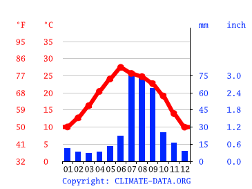
Aguascalientes The prevailing climate in Aguascalientes is known as a local steppe climate. Throughout the year, precipitation is scarce in Aguascalientes. The climate is classified as BSh according to Köppen and Geiger. The temperature here averages 18.2 °C | 64.7 °F. The precipitation level on a yearly basis amounts to 532 mm | 20.9 inch as per the meteorological records.

Graphs

Climograph, Aguascalientes average temperature by month, Aguascalientes

Click one of the graphs for more information.

León

León The local steppe climate exerts a significant influence on the weather patterns of León. In León, there is little rainfall throughout the year. As per the Köppen-Geiger classification, the prevailing weather conditions in this region are categorized under BSh. The temperature here averages 18.9 °C | 66.0 °F. Each year, there is an approximate 621 mm | 24.4 inch of precipitation that occurs.

Graphs

Climograph, León average temperature by month, León

Click one of the graphs for more information.

Monterrey

Monterrey The weather conditions in Monterrey are characterized by a mild and moderate climate. It is noteworthy that Monterrey experiences a considerable volume of precipitation throughout the year, including its least humid month. The climate is classified as Cfa according to Köppen and Geiger. The mean temperature prevailing in the city of Monterrey is recorded as 21.3 °C | 70.3 °F, according to statistical data. Precipitation here is about 609 mm | 24.0 inch per year.

Graphs

Climograph, Monterrey average temperature by month, Monterrey

Click one of the graphs for more information.

Querétaro

Querétaro The climatic conditions prevailing in Querétaro are characterized by a warm and moderate temperature. When compared with winter, the summers have much more rainfall. The Köppen-Geiger climate classification identifies this particular weather pattern as belonging to the category of Cwb. The average temperature in Querétaro is 17.9 °C | 64.1 °F. The precipitation level on a yearly basis amounts to 690 mm | 27.2 inch as per the meteorological records.

Graphs

Climograph, Querétaro average temperature by month, Querétaro

Click one of the graphs for more information.

Chihuahua

Chihuahua The climate here is considered to be a local steppe climate. There is not much rainfall in Chihuahua all year long. According to Köppen and Geiger, this climate is classified as BSh. The average annual temperature in Chihuahua is 18.9 °C | 66.1 °F. Approximately 332 mm | 13.1 inch of rainfall occurs on a yearly basis.

Graphs

Climograph, Chihuahua average temperature by month, Chihuahua

Click one of the graphs for more information.

Mexico in January
Mexico in February
Mexico in March
Mexico in April
Mexico in May
Mexico in June
Mexico in July
Mexico in August
Mexico in September
Mexico in October
Mexico in November
Mexico in December

Popular places

  •  Climate United States of America
  •  Climate Brazil
  •  Climate Canada
  •  Climate London
  •  Climate Australia
  •  Climate Tokyo
  •  Climate Italy
  •  Climate Amazonas
  •  Climate Savanna
  •  Climate France
  •  Climate Spain
  •  Climate Sydney
  •  Climate Paris
  •  Climate Toronto
  •  Climate New York
  •  Climate Japan
  •  Climate Mexico
  •  Climate Los Angeles
  •  Climate Vancouver
  •  Climate China

Top Locations in October

  •  New England
  •  New Jersey
  •  Ibiza
  •  South Korea
  •  Barcelona
  •  Istanbul
  •  Rhodes
  •  Vienna
  •  Dolomites
  •  Italy
  •  Beijing
  •  Medjugorje
  •  Guangzhou
  •  Red River Gorge
  •  Paris
  •  Chicago
  •  Antalya
  •  Las Vegas
  •  Hong Kong
  •  Balkan

Top Locations in November

  •  Morocco
  •  Florida
  •  Seoul
  •  Dollywood
  •  New Zealand
  •  Istanbul
  •  Paris
  •  Beijing
  •  Germany
  •  Hong Kong
  •  Red River Gorge
  •  Southern California
  •  Mecca
  •  Balkan
  •  Croatia
  •  Guangzhou
  •  Sharm el-Sheikh
  •  Jiangxi
  •  Rome
  •  South Korea

Popular places

 Mexico City
 Tijuana
 Guadalajara
 Puebla
 Ciudad Juárez
 Aguascalientes
 León
 Zapopan
 Monterrey
 Querétaro
 Gómez Palacio
 Mérida
 Mexicali
 Chihuahua
 Hermosillo
 Saltillo
 Acapulco
 Torreón
 Reynosa
 Morelia
 Cancún
 Durango
 San Pedro Tlaquepaque
 Apodaca
 Xalapa
 Mazatlán
 Veracruz
 Irapuato
 Tepic

Regions

Aguascalientes
Campeche
Chiapas
Chihuahua
Coahuila
Colima
Durango
Federal District
Guanajuato
Guerrero
Hidalgo
Jalisco
Lower California
Mexico
Michoacán
Morelos
Nayarit
Nuevo León
Oaxaca
Puebla
Querétaro
Quintana Roo
San Luis Potosi
Sinaloa
Sonora
South Lower California
Tabasco
Tamaulipas
Tlaxcala
Veracruz
Yucatán
Zacatecas

About
Data sources
Licensing
Translations
Advertising
Legal
Imprint
Privacy
© Climate-Data.org / AM OP / OpenStreetMap contributors